Iran’s Fordow Fuel Enrichment Plant (FFEP) has long been one of the most secretive and heavily fortified nuclear sites in the country, with satellite imagery providing crucial insights into its development and recent significant expansion12. Located approximately 30 kilometers north of the Iranian city of Qom, this mountain-hidden facility has become a focal point in international discussions about Iran’s nuclear ambitions34. Satellite images taken over the past two decades reveal a carefully concealed facility that has undergone substantial changes, culminating in a dramatic expansion of its enrichment capabilities in 2024-202556.
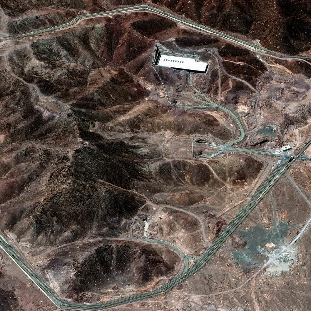
Satellite image of the Fordow Fuel Enrichment Plant (FFEP) showing its primary structures and surrounding access roads.
The Hidden Mountain Fortress
Built deep inside a mountain near the holy city of Qom, the Fordow facility was designed specifically to withstand aerial bombardment and other forms of attack78. Satellite imagery analysis reveals the facility is buried approximately 80-90 meters (260-295 feet) underground, making it one of Iran’s most heavily protected nuclear sites79. The mountainous terrain provides natural protection against conventional airstrikes, with only the tunnel entrances, support buildings, and security perimeter visible in overhead imagery1011.
The site’s strategic location was chosen deliberately, with the mountain’s geology providing exceptional protection against potential military strikes12. Analysis of satellite imagery shows the facility is constructed within a formation of hard sedimentary rock, potentially stronger than reinforced concrete, making it exceptionally difficult to breach even with advanced bunker-busting munitions2.
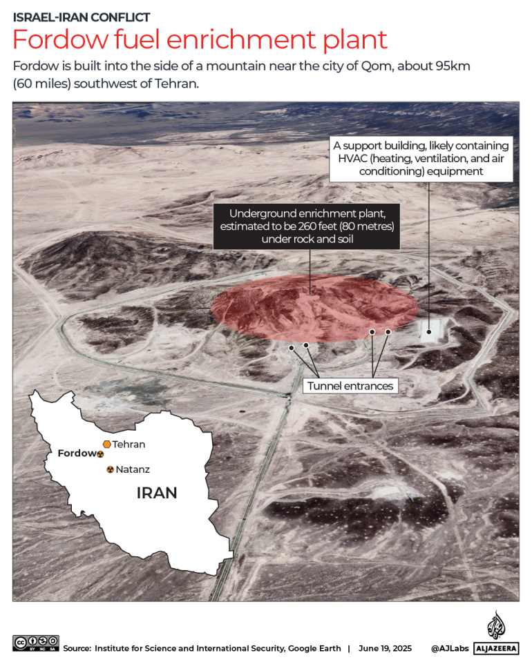
Annotated satellite image of Fordow fuel enrichment plant showing underground facility, tunnel entrances, and support building near Qom, Iran.
Early Construction Revealed Through Satellite Eyes
Satellite imagery has been instrumental in tracking Fordow’s development since its earliest days1314. The first signs of construction activity at the site date back to 2002, with commercial satellite imagery showing initial groundwork that wasn’t publicly acknowledged at the time1314. By 2004, satellite images clearly showed two covered tunnel entrances and a pile of earth spoils, indicating underground excavation activities1315.
Between 2006 and 2007, satellite imagery captured a significant increase in construction activity at the site, with new support structures and extensive earth-moving operations visible from space143. This period marked the beginning of the main construction phase for what would later be revealed as a uranium enrichment facility1416. Intelligence agencies had been monitoring these developments through satellite surveillance long before Iran officially disclosed the facility’s existence712.
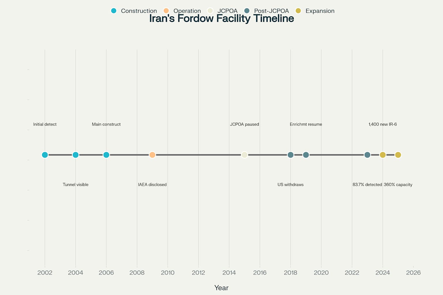
Timeline of Fordow Nuclear Facility Development Revealed Through Satellite Imagery (2002-2025)
Unveiling the Secret Facility
The world first learned about Fordow’s existence in September 2009, when Western intelligence agencies publicly exposed the site after monitoring its construction through satellite imagery for several years37. Iran subsequently confirmed the facility’s existence in a letter to the International Atomic Energy Agency (IAEA), though this disclosure came only after it became apparent that Western intelligence agencies were already aware of its presence717.
Satellite imagery from this period shows that by the time of disclosure, the facility already had significant external infrastructure completed, including large support buildings and well-developed tunnel entrances713. Maxar satellite imagery from 2009 reveals a security perimeter surrounding the site, access roads, and what analysts identified as ventilation shafts essential for an underground facility of this nature117.
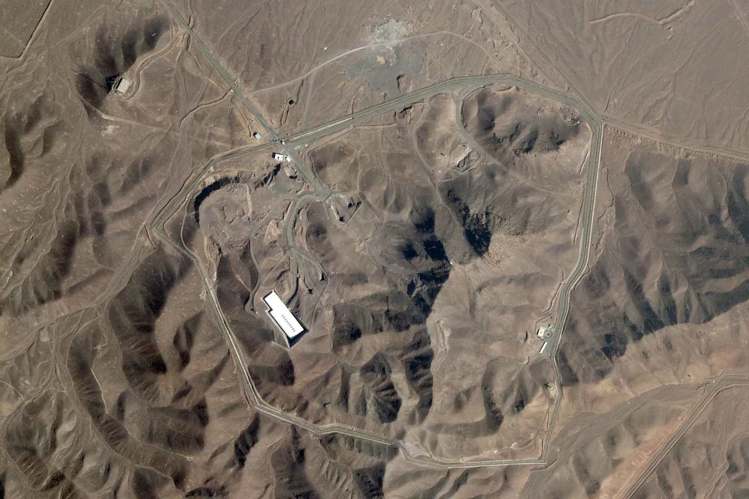
Satellite view of the Fordow Fuel Enrichment Plant in Iran, showing its layout and key structures within the arid landscape.
Physical Characteristics and Layout
Satellite imagery provides a unique perspective on Fordow’s physical layout and security features108. The most visible elements are the facility’s tunnel entrances, which appear as rectangular structures built into the mountainside811. These entrances serve as the primary access points to the underground enrichment halls that contain the centrifuges72.
Maxar satellite imagery shows several support buildings located outside the mountain, likely housing electrical systems, cooling equipment, and other infrastructure necessary for the operation of the underground facility1011. A security perimeter surrounds the entire complex, with access roads carefully laid out to control entry to the sensitive site117. The site’s footprint has expanded over time, with satellite imagery documenting the gradual addition of new structures and security features115.
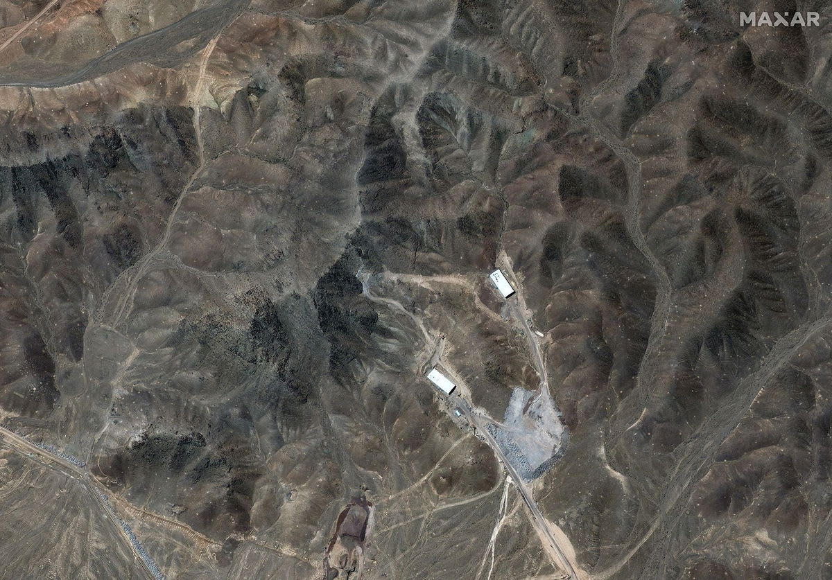
Maxar satellite image showing Fordow’s tunnel structures built into mountainous terrain.
The Invisible Underground Complex
While satellite imagery can reveal the above-ground elements of Fordow, much of the facility remains hidden beneath the mountain710. According to analysis of intelligence reports and IAEA inspections, the underground portion consists of two large halls, approximately 54,000 square feet in total, designed to house thousands of centrifuges for uranium enrichment187. The tunnels visible in satellite imagery lead to these subterranean chambers, which are estimated to be 80-90 meters below the surface72.
The underground design makes Fordow exceptionally resistant to potential military strikes, with experts suggesting that most conventional weapons would be unable to reach the deeply buried enrichment halls78. Satellite imagery has captured the entrances to ventilation shafts, which are critical for the operation of the underground facility but represent potential vulnerabilities in its otherwise formidable defenses7.
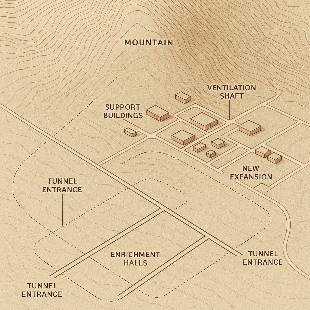
Schematic diagram showing the layout of Iran’s Fordow nuclear facility, including underground structures hidden beneath the mountain
The JCPOA Period: Changes Visible from Above
The implementation of the Joint Comprehensive Plan of Action (JCPOA) in 2015 brought significant changes to Fordow, many of which were visible in satellite imagery319. Under the terms of the agreement, Iran was required to halt uranium enrichment at Fordow and convert the facility into a nuclear physics and technology center320. Satellite images from this period show reduced activity at the site, with fewer vehicles present and no signs of expansion2019.
During this period, approximately two-thirds of the centrifuges inside Fordow were removed, a process that was verified by IAEA inspectors and partially visible through changes in the support infrastructure captured in satellite imagery320. The facility was banned from any nuclear-related work for 15 years under the agreement, temporarily eliminating the threat that had prompted international concerns34. Satellite monitoring during this period showed the facility remained largely unchanged between 2015 and 20182019.
Resumption of Activities: Post-JCPOA
Following the United States’ withdrawal from the JCPOA in May 2018, satellite imagery began to show renewed activity at Fordow319. In October 2019, the Israeli company ImageSat published satellite photographs showing renewed construction and development at the facility, indicating Iran’s intent to resume operations there312. By November 2019, Iran had announced it would resume uranium enrichment at Fordow, a decision that was soon confirmed by IAEA inspectors321.
Satellite imagery from this period shows increased vehicle activity, new security measures, and modifications to support buildings, suggesting preparations for expanded operations2111. The resumption of enrichment activities at Fordow represented a significant step in Iran’s move away from its JCPOA commitments, with satellite imagery providing crucial evidence of these changes for international observers319.
The Dramatic Expansion: 2024-2025
The most significant development at Fordow, clearly documented through satellite imagery, began in 2024 with a major expansion of the facility’s enrichment capabilities522. In June 2024, satellite images captured new construction activity at the site, coinciding with Iran’s notification to the IAEA that it planned to install eight additional cascades of advanced IR-6 centrifuges at Fordow225. This expansion would dramatically increase the site’s uranium enrichment capacity226.
The Washington Post reported that the planned installation of nearly 1,400 new centrifuges would triple Fordow’s enrichment capacity, potentially enabling Iran to produce weapon-grade uranium much more rapidly if it chose to do so56. Satellite imagery from Maxar Technologies showed construction activities related to this expansion, including modifications to support buildings and infrastructure upgrades necessary to accommodate the advanced centrifuges115.
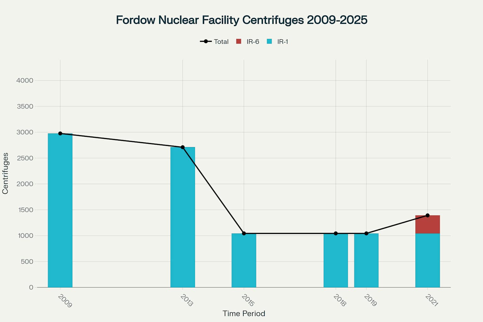
Evolution of Centrifuge Capacity at Fordow Nuclear Facility (2009-2025)
Centrifuge Expansion: The Heart of Fordow’s Growth
The most consequential aspect of Fordow’s recent expansion is the installation of advanced IR-6 centrifuges, which represent a significant technological upgrade compared to the older IR-1 models225. While this change is not directly visible in satellite imagery, the supporting infrastructure required for this expansion can be observed from space511. The IR-6 centrifuges are Iran’s most powerful deployed model, with each machine having more than ten times the enrichment capacity of the original IR-1 centrifuges2223.
In May 2024, Fordow had six cascades of IR-1 centrifuges and two cascades of IR-6 centrifuges, but Iran’s expansion plan called for adding eight more IR-6 cascades, bringing the total to ten IR-6 cascades and six IR-1 cascades225. This represents a 360% increase in Fordow’s total enrichment capacity, dramatically enhancing the facility’s capabilities226. The physical modifications necessary to support this expansion included new cooling systems, power supply upgrades, and possibly additional ventilation systems, some of which were visible in satellite imagery511.
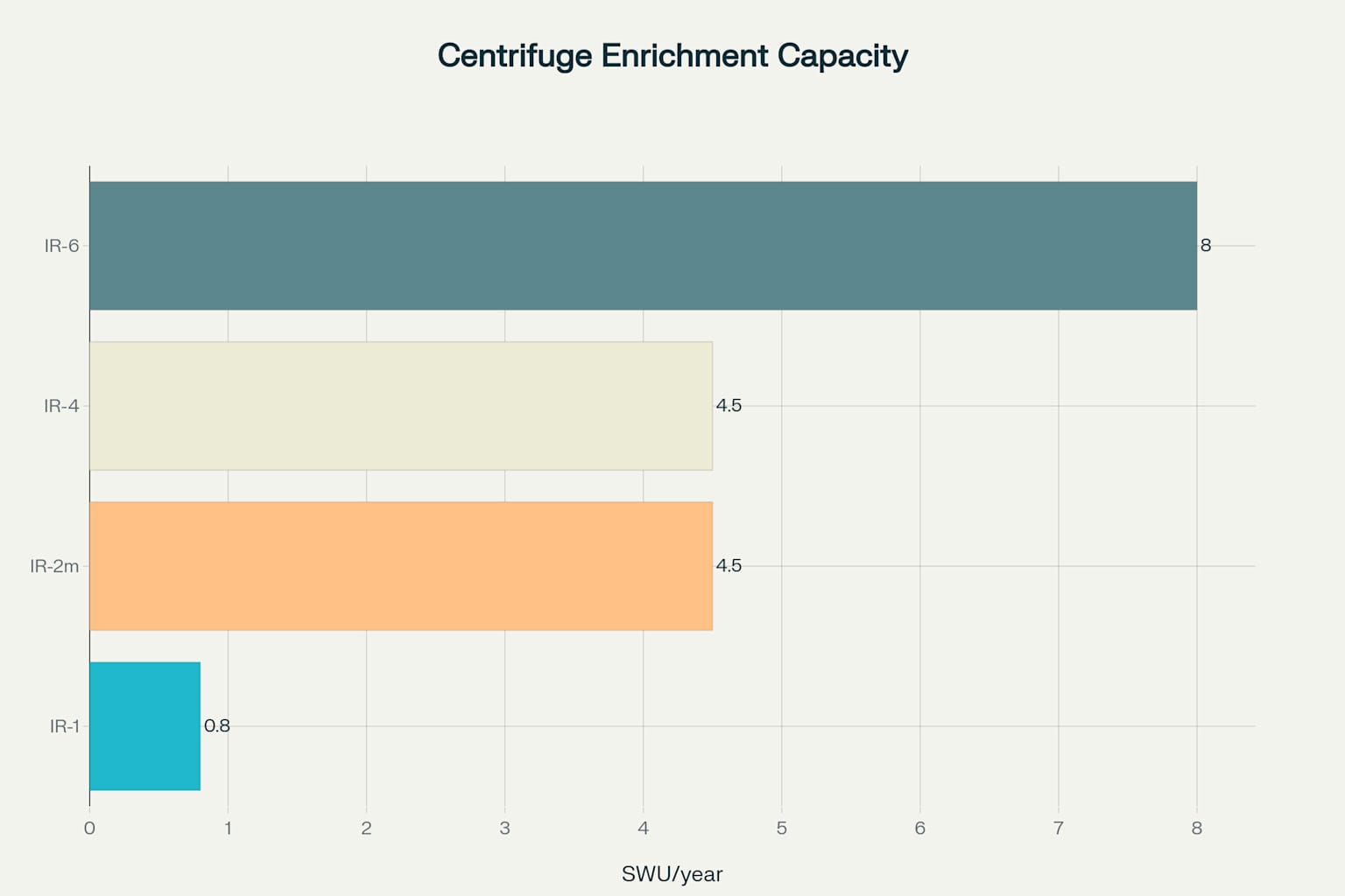
Enrichment Capacity of Iranian Centrifuge Models
Security Features and Defensive Measures
Satellite imagery reveals extensive security measures surrounding the Fordow facility, reflecting its strategic importance to Iran’s nuclear program811. The site is enclosed by a security perimeter that has been expanded and reinforced over time, with checkpoints controlling access to the sensitive areas118. Analysts have identified what appear to be defensive positions and surveillance systems designed to protect against potential ground attacks or infiltration812.
In 2016, satellite imagery showed Iran had stationed S-300 anti-aircraft missile systems at the site, significantly enhancing its air defenses38. These defensive systems, visible in satellite imagery as distinctive launchers and radar installations, were part of Iran’s strategy to protect its most crucial nuclear sites from aerial attack812. The mountainous terrain surrounding Fordow provides natural concealment for these defensive systems, making them more effective against potential threats87.
Recent Satellite Observations: 2025
The most recent satellite imagery from 2025 shows the Fordow facility in its fully expanded state, with all planned modifications apparently completed2425. According to analysis from the Institute for Science and International Security, the expanded facility now has the capability to produce enough weapons-grade uranium for multiple nuclear weapons in a matter of weeks if Iran chose to pursue that path2422. The site’s enhanced capacity makes it a critical component of Iran’s nuclear infrastructure2418.
Satellite imagery from June 2025 captured by Maxar Technologies shows what appears to be a fully operational facility with completed support structures and security features2511. While the June 2025 Israeli airstrikes targeted several Iranian nuclear facilities, satellite imagery analysis indicates that Fordow remained largely unscathed due to its underground protection1011. The Times of Israel reported that satellite imagery showed only limited damage to a retaining wall outside the facility, with the underground enrichment halls appearing to be undamaged2627.
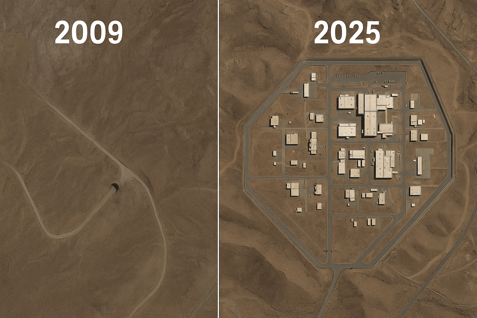
Satellite view comparison showing the evolution of Fordow nuclear facility from 2009 (left) to 2025 (right), highlighting visible expansion
Comparison with Other Iranian Nuclear Sites
Satellite imagery provides a useful comparison between Fordow and Iran’s other major nuclear facilities, particularly the Natanz enrichment plant1011. Unlike Natanz, which has significant above-ground components that were damaged in recent Israeli strikes, Fordow’s underground design makes it much more resistant to attack102. Imagery from both sites shows the different approaches to facility design, with Fordow prioritizing protection while Natanz emphasizes production capacity1011.
The Natanz facility, as seen in satellite imagery, is much larger in scale than Fordow but more vulnerable to aerial attack103. Satellite images from the Institute for Science and International Security show that Iran has been constructing a new underground complex at Mount Kolang Gaz La near Natanz, apparently learning from Fordow’s protective design1528. This new complex, like Fordow, features tunnel entrances leading deep under a mountain peak, suggesting Iran is replicating the protective features that have made Fordow so resilient1528.
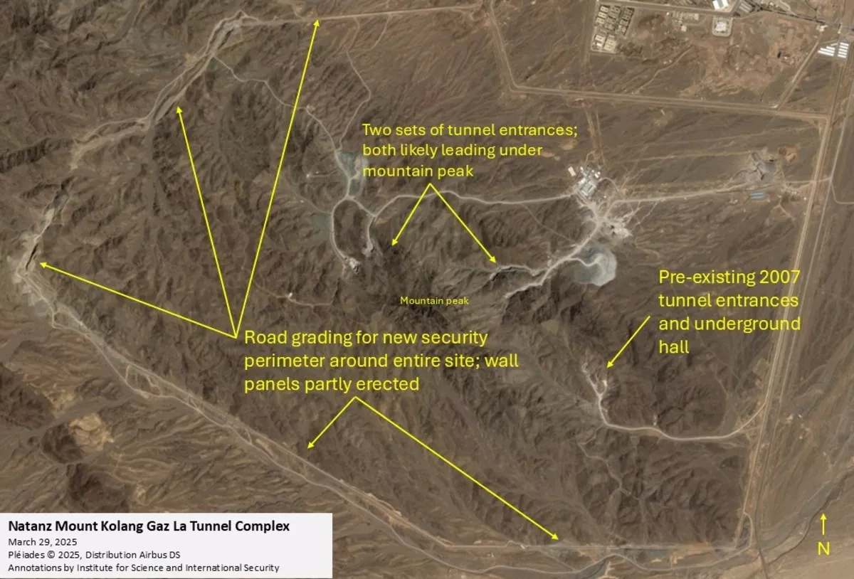
Annotated satellite imagery of the Natanz Mount Kolang Gaz La Tunnel Complex, detailing new tunnel entrances and ongoing security perimeter construction.
The Challenge of Monitoring Through Satellite Imagery
While satellite imagery has been crucial for tracking Fordow’s development, it has significant limitations when monitoring such a heavily hardened underground facility107. Most of the critical components of Fordow—particularly the centrifuge halls—are invisible to satellite observation, requiring intelligence agencies and the IAEA to rely on additional sources of information72. The facility’s design specifically minimizes its satellite-visible footprint, with most activities taking place deep underground78.
Analysts must infer activities from subtle changes in the visible infrastructure, such as new construction, vehicle movements, and modifications to support buildings117. During the June 2025 conflict, when Israeli strikes targeted Iranian nuclear facilities, satellite imagery from Planet Labs and Maxar Technologies was instrumental in assessing damage to various sites, though it revealed little about Fordow’s underground status1025. This underscores both the value and limitations of satellite monitoring for such facilities107.
Implications of Fordow’s Expansion
The significant expansion of Fordow’s enrichment capacity, documented through satellite imagery and IAEA reports, has profound implications for regional security and nuclear nonproliferation efforts2224. The facility’s heavily protected design and recent technological upgrades make it what analysts call Iran’s “breakout option”—a facility that could continue enriching uranium even if other sites were disabled22. With its enhanced capacity, Fordow could potentially produce enough weapons-grade uranium for several nuclear weapons in a matter of weeks2224.
The 2024-2025 expansion, clearly visible in support infrastructure changes captured by satellite imagery, has shortened Iran’s potential timeline to produce weapons-grade uranium, should it choose to do so225. According to analysis from the Institute for Science and International Security, the expanded Fordow facility could produce 92 kg of weapons-grade uranium within one-third of a month after commencing breakout, enough for three nuclear weapons2229. This capability, protected deep within a mountain, represents a significant challenge for international nonproliferation efforts2918.
Conclusion: What the Eyes in the Sky Reveal
Satellite imagery has played a crucial role in uncovering and monitoring Iran’s Fordow nuclear facility, from its secretive beginnings to its recent dramatic expansion1322. The images from space have revealed a carefully concealed facility designed to withstand military attack, with recent modifications significantly enhancing its uranium enrichment capabilities722. The 2024-2025 expansion, adding 1,400 advanced IR-6 centrifuges, represents a 360% increase in enrichment capacity that transforms Fordow into a much more potent facility225.
Despite the limitations of satellite monitoring for underground facilities, imagery analysis has provided invaluable insights into Fordow’s development, security features, and operational status107. As international tensions continue over Iran’s nuclear program, satellite imagery remains a critical tool for transparency and verification1025. The evolution of Fordow, as documented from space, tells a story of increasing sophistication and capacity that will continue to be closely watched by intelligence agencies and nuclear nonproliferation experts around the world1122.
Footnotes
-
https://www.nbcnews.com/world/iran/iran-israel-war-fordo-nuclear-site-trump-negotiations-reactors-rcna213923 ↩
-
https://www.cbsnews.com/news/massive-ordnance-penetrator-bomb-gbu-57-b-2-bomber-iran-fordo-nuclear-facility/ ↩ ↩2 ↩3 ↩4 ↩5 ↩6
-
https://en.wikipedia.org/wiki/Fordow_Fuel_Enrichment_Plant ↩ ↩2 ↩3 ↩4 ↩5 ↩6 ↩7 ↩8 ↩9 ↩10 ↩11 ↩12 ↩13
-
https://www.nti.org/education-center/facilities/fordow-fuel-enrichment-plant/ ↩ ↩2
-
https://www.washingtonpost.com/world/2025/06/12/iran-nuclear-sites-explained-israel-attack/f4355712-4805-11f0-9210-87ee82efcc80_story.html ↩ ↩2 ↩3 ↩4 ↩5 ↩6 ↩7 ↩8 ↩9 ↩10 ↩11 ↩12
-
https://isis-online.org/isis-reports/detail/technical-note-irans-recent-increase-in-enrichment-capacity-at-fordow/8 ↩ ↩2 ↩3 ↩4
-
https://www.cnn.com/2025/06/17/middleeast/iran-fordow-nuclear-site-latam-hnk-intl ↩ ↩2 ↩3 ↩4 ↩5 ↩6 ↩7 ↩8 ↩9 ↩10 ↩11 ↩12 ↩13 ↩14 ↩15 ↩16 ↩17 ↩18 ↩19 ↩20 ↩21 ↩22
-
https://news.sky.com/story/fordow-what-we-know-about-irans-secretive-nuclear-mountain-and-how-israel-might-try-to-destroy-it-13385834 ↩ ↩2 ↩3 ↩4 ↩5 ↩6 ↩7 ↩8 ↩9 ↩10 ↩11
-
https://www.bloomberg.com/graphics/2025-israel-targets-iranian-nuclear-sites/ ↩
-
https://www.bbc.com/news/articles/c7808xvv737o ↩ ↩2 ↩3 ↩4 ↩5 ↩6 ↩7 ↩8 ↩9 ↩10 ↩11 ↩12 ↩13 ↩14
-
https://www.businessinsider.com/images-show-damage-iran-nuclear-facility-after-israel-strikes-2025-6 ↩ ↩2 ↩3 ↩4 ↩5 ↩6 ↩7 ↩8 ↩9 ↩10 ↩11 ↩12 ↩13 ↩14 ↩15 ↩16 ↩17 ↩18
-
https://www.dw.com/en/fordo-the-heart-of-irans-nuclear-program/a-72955781 ↩ ↩2 ↩3 ↩4 ↩5
-
https://www.i24news.tv/en/news/israel/defense/artc-israel-poised-to-strike-iran-s-fordow-nuclear-site-with-or-without-u-s-support ↩ ↩2 ↩3 ↩4 ↩5
-
https://www.understandingwar.org/backgrounder/iran-update-special-report-june-15-2025-morning-edition ↩ ↩2 ↩3 ↩4
-
https://isis-online.org/isis-reports/detail/new-security-perimeter-around-mt.-kolang-gaz-la-tunnel-complex/ ↩ ↩2 ↩3
-
https://missiledefenseadvocacy.org/missile-threat-and-proliferation/todays-missile-threat/iran/fordow-uranium-enrichment-plant/ ↩
-
https://www.aljazeera.com/news/2025/6/19/what-is-irans-fordow-nuclear-facility-and-could-us-weapons-destroy-it ↩
-
https://www.csis.org/analysis/options-targeting-irans-fordow-nuclear-facility ↩ ↩2 ↩3
-
https://www.csis.org/analysis/three-things-will-determine-irans-nuclear-future-fordow-just-one-them ↩ ↩2 ↩3 ↩4 ↩5
-
https://thehill.com/policy/international/5359296-iran-fordow-nuclear-site-israel-iran-conflict/ ↩ ↩2 ↩3 ↩4
-
https://www.euronews.com/2025/06/19/what-is-irans-fordow-nuclear-site-and-why-is-it-so-critical-to-the-conflict ↩ ↩2
-
https://www.armscontrol.org/act/2024-07/news/reacting-censure-iran-expands-enrichment-activities ↩ ↩2 ↩3 ↩4 ↩5 ↩6 ↩7 ↩8 ↩9 ↩10 ↩11 ↩12 ↩13 ↩14 ↩15 ↩16 ↩17
-
https://www.iranwatch.org/our-publications/weapon-program-background-report/irans-centrifuges-models-status ↩
-
https://www.euronews.com/2025/06/16/in-pictures-aftermath-of-israeli-strikes-on-irans-military-and-nuclear-sites ↩ ↩2 ↩3 ↩4 ↩5
-
https://www.ynetnews.com/health_science/article/bydahnzvgx ↩ ↩2 ↩3 ↩4
-
https://www.timesofisrael.com/liveblog_entry/images-from-space-appear-to-show-limited-damage-at-fordo-nuclear-site/ ↩
-
https://isis-online.org/isis-reports/detail/irans-natanz-tunnel-complex-deeper-larger-than-expected/8 ↩ ↩2